Operational Remote Sensing
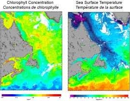
Welcome to operational remote sensing. Data for images is captured in real time at the receiving station of the Ocean Research and Monitoring Section, Bedford Institute of Oceanography. Sea-surface temperature images are derived from information sensed by the AVHRR instruments flown on the NOAA series of satellites. The 200 meter bathymetry is shown on these images. Chlorophyll concentration images are produced from SeaWiFS data collected on the OrbView-2 satellite.
Primary Production images are derived from the semi-monthly composites of chlorophyll concentration and temperature. The motivation behind this work is to generate a time series of images describing the state of the NW Atlantic, with respect to its physical and biological condition, that can be used as a research tool in the study of the interrelation between fisheries and ecosystem functions. The value of the series will grow as its duration increases.
The following images have been produced:
- Semi-monthly composites of the Atlantic Zone - These images cover the area 39 N to 62.5 N and 42 W to 71 W and have a data resolution of about 1.5 km per pixel. The resolution has been reduced to approximately 2 km per pixel for display on this web site. All of the data available for each half month are combined to produce a composite image. Where there are multiple pixels at any location, they are averaged.
- Individual satellite passes for pre-defined areas - Nine areas have been selected for processing into images of 512x512 pixels. Each satellite pass received is processed into these nine areas.
- Quarter-monthly composites of the Extended Atlantic Zone< - These images cover the area 39 N to 82 N and 42 W to 95 W and have a data resolution of about 4 km per pixel. All of the data available for each quarter month are combined to produce a composite image. Where there are multiple pixels at any location, they are averaged.
This service is no longer supported. We are working on a new platform to distribute these datasets. Please check back shortly for new links. For more information contact Emmanuel Devred (Emmanuel.Devred@dfo-mpo.gc.ca) or Stephaine Clay (Stephanie.Clay@dfo-mpo.gc.ca).
Use of the SeaWiFS data for scientific research is granted courtesy of NASA.
- Date modified: