Ocean Waves
We present a new method for estimating how ocean waves interact with one another, through nonlinear transfer of energy and action. This approach is based on a two-scale approximation (TSA) to the full Boltzman integral (FBI) for quadruplet wave-wave interactions and we tested this new method for idealized spectral data. Here, we focus on comparisons of the TSA and the Discrete Interaction Approximation (DIA) to the FBI for observed wave spectral from field measurements. Observed wave spectra are taken from a wave gage array in Currituck Sound and a directional waverider off the coast near the Field Research Facility (FRF) at Duck, North Carolina. Results show that the TSA compares much more favorably with the FBI than the DIA, even for cases in which the broad-scale component of the formulation does not capture the spectral energy distribution very well. These results remain valid for the TSA estimates when the FBI results are significantly affected by the directional distribution of energy. We also show that although nonlinear transfers are substantially weaker in swell portions of the spectrum, these interactions contribute significantly to the spectral evolution and net energy balance in long-distance swell propagation.

(a)
(d)
(g)

(b)

(e)

(f)

(c)
(f)

(i)
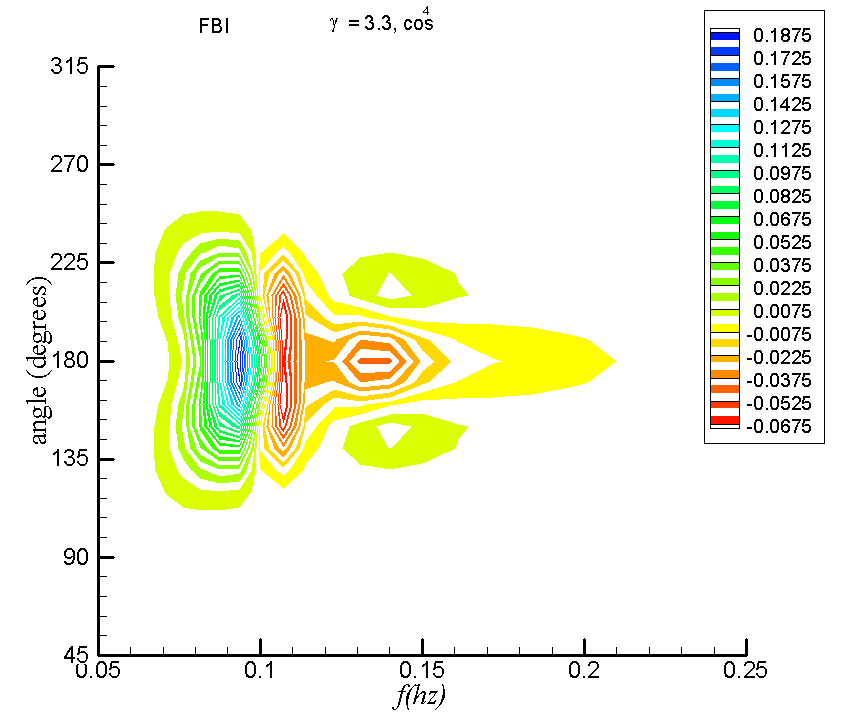
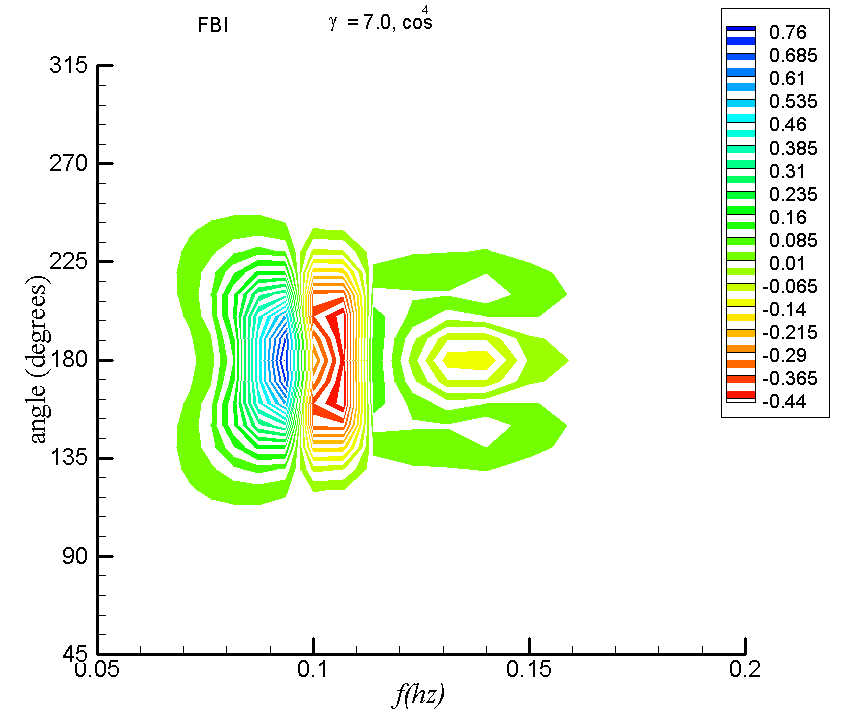
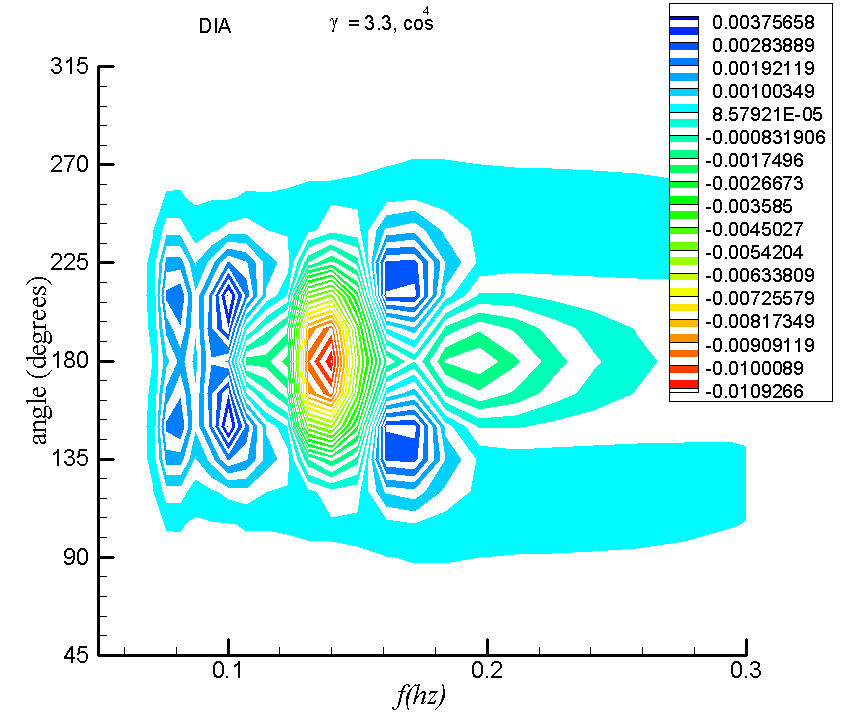
Contours of Snl(f,θ) as a function of angle θ and frequency f for (a) the full Boltzmann integral (FBI) and (b) TSA, (c) DIA, for a JONSWAP spectrum with a cos4 angular distribution centered at 180° for spectral peakedness γ= 1. Units are m2. Note that (d), (e), (f) use γ= 3.3, and (g), (h), (i) use γ= 7.0.
On the Impacts of Climate Change and the Upper Ocean on Landfalling Cyclones
This study explores the characteristics of the air-sea interactions and extratropical autumn storms in the Northwest Atlantic. Simulations are performed with a relatively fine resolution coupled atmosphere-ocean model system. The model system consists of the Canadian Mesoscale Compressible Community (MC2) atmospheric model coupled to a recent version of the Princeton Ocean model (POM). Atmospheric boundary conditions for storm simulations are given by the Canadian Climate Centre model, CGCM2 (Second Generation Coupled Global Climate Model), following the IPCC IS92a scenario conditions. The CGCM2 control conditions are obtained from simulated years 1975-1994. Our results show that interactions between extratropical storms and the upper ocean are affected by the upper ocean, latent and sensible heat fluxes across the air-sea interface, and the atmospheric structure, which propagates relative to the ocean surface as storms move along their storm tracks. Three types of numerical storm experiments are conducted, for storms that (i) make landfall, (ii) move along the coastline without landfall, and (iii) remain over the open ocean. Our results suggest that the locations of the maximum storm-induced sea surface temperature cooling are mainly dominated by the upper ocean thermostructure. The storm's intensity, as represented by its maximum wind speed, can cause further SST cooling. In turn, the upper ocean can reduce storm intensity by as much as 4-5 hPa in minimum sea level pressure, or 2-4 m s-1 in surface winds. Although the impacts of these effects are most notable in the lower atmospheric boundary layer, they extend to the top of the troposphere.
The Vertical Temperature Profiles

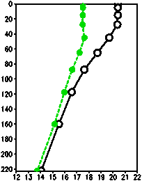
(a) at (41°N, 53°W)

(b) at (41°N, 48°W)
Pre-storm profile (-) is compared to post-storm profile (-).Units for the y-axis in each case are m. This is the open ocean storms case.
An Unstructured-Grid Finite-Volume Wave Model (FVCOM-SWAVE)
The structured-grid surface wave model SWAN (Simulating Wave Nearshore) has been converted into an unstructured-grid finite-volume version (hereafter referred to as FVCOM-SWAVE) for use in coastal ocean regions with complex irregular geometry. The implementation is made using the Flux-Corrected Transport (FCT) algorithm in frequency space, the implicit Crank-Nicolson method in directional space and the second-order finite-volume, explicit or implicit upwind schemes in geographic space. FVCOM-SWAVE was validated for three benchmark test problems with emphasis on numerical dispersion, wave-current interactions, wave propagation over a varying-bottom shallow water region, and the basic wave grow curves. Results show that in the rectangular geometric domain, the second-order finite-volume method used in FVCOM-SWAVE has the same accuracy as the third-order finite-difference method used in SWAN. FVCOM-SWAVE was then applied to simulate wind-induced surface waves on the US northeast shelf with a central focus in the Gulf of Maine and New England Shelf. Through improved geometric fitting of the complex irregular coastline, FVCOM-SWAVE was able to robustly capture the spatial and temporal variation of surface waves in both deep and shallow regions along the US northeast coast.
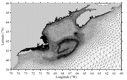
Unstructured triangular grid in the Gulf of Maine and New England Shelf region, with horizontal resolution varying from about 25 km off Georges Bank to 0.5-1.0 km near the coast.
Gulf Stream thermal fronts detected by synthetic aperture radar
Our purpose is to detect ocean surface features, specifically oceanic thermal fronts, through analysis of SAR (synthetic aperture radar)-derived wind stress fields. Fine-resolution measurements of near-surface wind speeds over the Gulf Stream region of the Northwest Atlantic were made using SAR images collected by RADARSAT-2. Linear statistical relationships between the wind stress curl and divergence to the crosswind and downwind components of the SST gradient field were used to derive a new method for detecting Gulf Stream thermal fronts from Synthetic Aperture Radar (SAR) imagery. In particular, sea surface temperature front features, as suggested by corresponding AVHRR and MODIS images, are evident in both of the wind stress curl and divergence fields. The importance of this methodology is that clouds are often present in the Northwest Atlantic in autumn and winter months and they obscure AVHRR and MODIS images, whereas SAR can penetrate clouds.

(a) SAR image at 22:12:12 UTC on May 22, 2009

(b) co-located SST image at 17:46:48 UTC on May 22, 2009

(c) SST gradient image corresponding to the bottom portion of the SAR image in (a)
(d) wind stress perturbation image computed from SAR image.
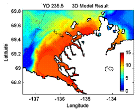
Dynamics of the Mackenzie River plume on the inner Beaufort Shelf during summer
The oceanographic conditions of the Mackenzie River plume in the Arctic Ocean were examined during a 12-day period in August 2007. Field observations in the river channel and the delta region (2~6 m depth), ship-based observations on the shelf and satellite observations of sea surface temperatures indicate that movements of plume density fronts cause changes in water temperatures of over 10 C over a few days. We used a 1D model to compare the strength of stratification versus surface wind stress, and a 3D numerical model to simulate the plume motions under forcing from the river flows, local wind and water level variations from tides and wind-driven surge. The results indicate that the coastal region is stratified with a ~2 m thick surface plume even in water depths of 3e4 m, resulting in strong vertical variation of horizontal currents. Moderate easterly winds of 5e10 m/s are sufficient to induce offshore transport of the surface plume and onshore transport of the deeper shelf water, leading to large fluctuations in temperature and salinity in the coastal region. This study examined a period of offshore transport and mean water level set-down, and indicates the rapid response of the plume to wind over the shallow delta.
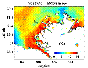
(a)
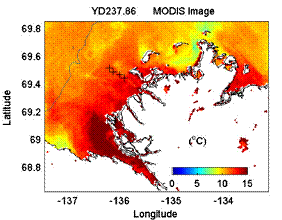
(b)
(c)

(d)
a)-b) Sea surface temperatures from MODIS satellite observations in August 2007, showing the extent of the Mackenzie River plume in the delta region. Easterly winds cause upwelling, stronger mixing and lower temperature of the plume in a); light winds with minimal mixing and entrainment of underlying shelf water allow the higher temperature plume to spread as a thin surface layer in b). c)-d) Model results for sea surface temperature at the same times as satellite data, indicating movement of the plume though the instrument array denoted by crosses.
- Date modified: