Minas Basin Sea Level (Bay of Fundy)
During 2002-03, the Canadian Space Agency (CSA) funded a collaborative project involving BIO/OSD, the Center for Geographic Sciences (Lawrencetown, N.S.), the Canadian Hydrographic Service and the Canada Centre for Remote Sensing to predict sea level in Minas Basin and to compare estimated positions of the variable land-water boundary (coastline) obtained from remote sensing and a numerical modelling system. The underlying motivation was the development of improved observational and predictive capabilities for the coastline position, such as during extreme tides and/or storm surges.
The Applied Geomatics Research Group (AGRG) of the Center of Geographic Sciences (COGS) extended and applied grey-level thresholding methods to extract the coastline position from RADARSAT-1 SAR, Landsat and IKONOS satellite images at different times in Minas Basin. See the citation for Milne (2003) below for a report and a powerpoint presentation on these analyses.
OSD implemented a high-resolution numerical tidal/flood modelling system to predict sea level in Minas Basin from which the varying coastline position could be extracted. See Dupont et al. (2003) for a manuscript describing the application and observational evaluation of the modelling system. Overall the modelling system simulated the water level in Minas Basin with about a 10% error.
AGRG/COGS extracted coastline position at the time of the remote-sensing images from the model predictions and carried out comparisons of the remotely-sensed and predicted coastline positions. Examples of these images with the extracted and predicted coastlines are shown below. Discussions of the coastline comparisons and project results can be found in Dupont et al. (2003) and Milne (2003).
Predictions of sea level height in Minas Basin and other Atlantic Canadian coastal regions can be obtained from the WebTide Tidal Prediction System.
The project is built on work carried out during 2000-02 in a previous CSA-funded project. Reports by Stockhausen (2001) and Deneau (2002) on remote-sensing coastline extraction methods and evaluations carried out in the previous project are available from the AGRG/COGS website.
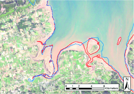
True colour Landsat-7 image of the Wolfville vicinity at 14:54:13 (GMT) on 13 Sept. 1999 (courtesy of Trevor Milne, AGRG). The green is vegetation and the sandy brown is exposed tidal flats. The red line is the instantaneous coastline extracted from one of the near infrared bands and the blue line is the coastline extracted from the tidal model.
Visually, there is good overall agreement between the modelled and retrieved land/water interface in the western part of the image, but the accuracy degrades in the east. Milne (2003) reports that the mean separation between the two coastlines is 141 m, with 14% of the points within 25 m and 37% within 100 m. An important source of discrepancy is local bathymetry. For example the lack of data in the channels between the mainland and Boot Island (large Island in the middle of the image), leads to the model underpredicting the shoreward extent of the land/water interface in this area.
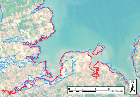
True colour Landsat-7 image of the Wolfville vicinity at 14:52:00 (GMT) on 13 July 2000 (courtesy of Trevor Milne, AGRG). This snapshot near high tide shows that the model overpredicts the inundation of large areas along the river beds on the eastern half of the area. This appears to be due to the fact that the dykes, while in the original topography data, are not resolved in the model (with 30 m) resolution. The analysis is reported in Milne (2003).
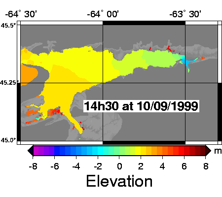
The image above links to an animated gif movie showing the tides in the Minas Basin during the period from Sept. 10 to Sept. 13, 1999. (26 MB)
Bibliography:
- Deneau, D., 2002: Extracting 3d coastlines from remotely sensed data. Project report for the Department of Fisheries and Oceans (DFO) and the Canadian Space Agency (CSA). Disponible auprès de Tim Webster, Applied Geomatics Research Group, Centre of Geographic Sciences, Middleton, N.-É., Canada.
- Dupont, F., C. G. Hannah, D. Greenberg. Modelling the sea level in the upper Bay of Fundy. In preparation for Atmosphere-Ocean. Download Dupont PDF (4 MB)
- Loder, J., 2003. Predictions and Comparisons of Geo-Referenced Sea Level in Minas Basin during Remote-Sensing Surveys in 1999 and 2000. Rapport final à l'Agence spatiale canadienne, Earth and Environment Applications Program: 2002/03. Download Loader PDF (101 KB)
- Milne, T., 2003: Tide model validation using remotely sensed data: Minas Basin N.S. Rapport de 68 pages. Disponible auprès de Tim Webster, Applied Geomatics Research Group, Centre of Geographic Sciences, Middleton, N.-É., Canada. Download Milne PDF (8 MB) Download Powerpoint Presentation Présentation PowerPoint (30 MB)
- Stockhausen, J., 2001. Evaluation of Polarimetric SAR Data for Assessment and Monitoring of Coastal Areas. Applied Geomatics Research Group (AGRG) Rapport sur le projet pour le Centre canadien de télédétection (CCT).
- Date modified: